import numpy as np

import dascore as dc

patch = dc.get_example_patch()Patch
A Patch couples an array with coordinate labels and metadata. Patch methods return new patches instead of modifying the original.
Creating patches
Examples and files
DASCore includes example patches for tutorials and tests:
event = dc.get_example_patch("example_event_1")Use dc.spool(...) to open DAS files and take a patch by indexing the spool:
file_patch = dc.spool("examples://terra15_das_1_trimmed.hdf5")[0]
Note
An examples:// name refers to a file in DASCore’s example data registry; it is downloaded and cached the first time it is used. Anywhere it appears in these docs, a path to your own data works just as well. Generated examples, which have no file behind them, come from dc.get_example_patch and dc.get_example_spool instead.
See the spool tutorial for directories, archives, and remote resources.
Arrays
To build a patch directly, supply the data, its dimension names, and coordinates. Attributes are optional.
rng = np.random.default_rng(13)
data = rng.random((300, 2_000))
time = dc.to_datetime64("2017-09-18") + np.arange(2_000) * dc.to_timedelta64(1 / 250)
distance = np.arange(300)

manual_patch = dc.Patch(
    data=data,
    dims=("distance", "time"),
    coords={"distance": distance, "time": time},
    attrs={"data_units": "um/(m * s)"},
)
Anatomy
Data and coordinates
Patch.data is an immutable n-dimensional array and must be treated as such; it generally cannot be changed in place. Copy it before changing values directly.
data_copy = np.array(patch.data)
data_copy[:10] = 0
Patch.coords manages dimension names and coordinates. The common accessors are available on the patch itself:
time_coord = patch.get_coord("time")
time_values = patch.get_array("time")
distance_max = patch.coords.max("distance")
time_step = patch.coords.step("time")
A coordinate may be associated with one or more dimensions, such as latitude along distance, or be independent of the data. See the advanced coordinates tutorial for direct BaseCoord and CoordManager use.
Dimension coordinates usually share a dimension’s name, but that is not required. Auxiliary coordinates such as latitude commonly depend on distance; a quality grid may depend on both distance and time; deployment metadata can be independent of every dimension.
String coordinates support exact matches, wildcards, compiled regular expressions, masks, and sorting, but not units or numeric ranges. See String coordinates for examples and literal-label caveats.
Metadata without data
PatchMeta is everything a patch is apart from its data: coordinates, attrs and dtype. Scanning a file returns these, so a patch’s shape and extents can be read without loading samples.
meta = patch.drop_data()
print(meta.shape, meta.dtype)

patch_again = meta.to_patch(patch.data)
(300, 2000) float64drop_data and to_patch are inverses. Operations which only describe data, such as rename_coords, run on a PatchMeta; those which compute samples need a Patch.
Attributes and summaries
Patch.attrs contains validated, non-coordinate metadata such as data_units, acquisition_key, gauge_length, and processing history. Coordinate bounds and steps are derived through Patch.summary rather than duplicated in attrs.
print(patch.attrs.data_units)
print(patch.summary.get_coord_summary("time").min)

row = patch.flat_dump()
print(row["time_min"], row["distance_step"])
None
2017-09-18T00:00:00.000000000
2017-09-18T00:00:00.000000000 1Patch.summary is read-only. flat_dump() is intended for tabular rows and produces the same coordinate-summary column names used by spool indexes, including time_min, time_max, and distance_step. The optional data_type attribute is a display hint; interpret data through its units, coordinates, and history.
A preview of the validated attribute schema is available programmatically:
attribute_fields = dc.PatchAttrs.get_summary_df()
attribute_fields.head()| description | |
|---|---|
| attribute | |
| data_type | Describes the quantity being measured. |
| data_category | Describes the type of data. |
| data_units | The units of the data measurements |
| acquisition_key | Inventory identity of the data source, spelled... |
| tag | A custom string field. |
Patch functions append to attrs.history. Disable new entries temporarily when provenance is not needed:
from dascore.config import config_context

with config_context(patch_history="disabled"):
    without_new_history = patch.abs()
Existing history remains intact while recording is disabled. This is useful for tight processing loops where a full operation log is unnecessary; leave the default enabled when results must be audited later.
Patch identity
Two attributes track identity:
| Attribute | Meaning | Changes when |
|---|---|---|
origin_id |
Which stored data this came from | Data from more than one origin is combined |
data_id |
Which array this is | An operation changes the patch |
A patch nothing has been done to carries its origin’s ID as its data_id. An operation’s result takes an ID derived from the data_id of every patch it was given, in order, and from the operation’s name, version, and parameters, so one ID commits to the whole route which led to it:
assert patch.attrs.data_id == patch.attrs.origin_id

filtered = patch.pass_filter(time=(1, 10))
assert filtered.attrs.origin_id == patch.attrs.origin_id
assert filtered.attrs.data_id != patch.attrs.data_id
The route matters. Repeating the same operations produces the same data_id, while changing their order does not:
first = patch.pass_filter(time=(1, 10)).decimate(time=2)
same = patch.pass_filter(time=(1, 10)).decimate(time=2)
other = patch.decimate(time=2).pass_filter(time=(1, 10))

assert first.attrs.data_id == same.attrs.data_id
assert first.attrs.data_id != other.attrs.data_id
A parameter left at its default is the same call as one which passes that default, so adding a defaulted parameter to an operation changes no ID; changing what a default does requires raising the operation’s version. An ID is never knowingly false: when a parameter cannot be described faithfully (a closure, an object of an unknown type), or an input carries no ID, the result receives a random data_id instead of a derived one.
Trimming a stored patch is not a route. While a patch is still exactly what its source loads, narrowing it to a window of that array names the window rather than the call which reached it, so dc.read(path, time=window), dc.read(path)[0].select(time=window) and spool.select(time=window) all name one array, and selecting twice lands where selecting once does. Once anything else has been done to the patch, or the selection is one the stored array cannot be sliced to, the result derives like any other operation’s. Reading under non-default decode options, such as snap=False, is itself an operation on the stored thing, so it names a different array than the default read of the same file.
When a file does not contain an origin_id, DASCore derives one from the format, version, path, patch key, file size, and modification time. Repeated reads and metadata scans therefore agree without hashing the data array. Copying the same bytes to another path produces a different derived ID, and overwriting a path also changes it. Formats that store the IDs (DASDAE) restore both when the file is read elsewhere, so a route continues across a save.
In-memory patches receive process-local IDs. The low-level methods — new, update, update_attrs, set_dims and to_patch — are how patch functions assemble their results, so inside an operation they add nothing: the operation names its own result. Called on their own they say what they did. Handing a patch an array nothing else names gives the result a random data_id, since no route describes it, while origin_id still says where the data came from:
doubled = patch.new(data=patch.data * 2)
assert doubled.attrs.origin_id == patch.attrs.origin_id
assert doubled.attrs.data_id != patch.attrs.data_id
Replacing metadata instead is a describable change, so the result’s ID is derived from the call and can be arrived at twice:
tagged = patch.update_attrs(tag="cleaned")
assert tagged.attrs.data_id == patch.update_attrs(tag="cleaned").attrs.data_id
assert tagged.attrs.data_id != patch.attrs.data_id
A call which changes nothing returns the patch’s own IDs, and stating origin_id or data_id in the call keeps what was stated — which is how a patch rebuilt by hand is given the identity it should carry. Use patch functions when processing should change the data_id; a function that returns the input unchanged changes neither ID, and IDs do not participate in Patch.equals. Set patch_provenance="disabled" only when IDs are not needed; a patch changed while it is disabled carries no IDs rather than stale ones. See Finding a patch by its ID for lookup.
Those IDs are derived without reading anything. pin_id reads the array instead and states a data_id hashed from the patch’s content, so patches which arrived by different routes share one ID and everything derived afterwards builds on data checked here:
pinned = patch.pin_id()
assert pinned.attrs.data_id == dc.get_example_patch().pin_id().attrs.data_id
assert pinned.pin_id().attrs.data_id == pinned.attrs.data_id
Pinning is a checkpoint rather than something every operation does. See Weak and strong data_id for what it hashes.
Display and shortcuts
Displaying a patch summarizes its data, coordinates, attributes, and history. HTML displays use collapsible sections; display_html selects the text representation instead.
patchCoordinates (distance: 300, time: 2000)
| kind | min | max | span | step | shape | dtype | |
|---|---|---|---|---|---|---|---|
| *distance | NumericCoord | 0 m | 299 m | <299 m> | 1 m | (300,) | int64 |
| *time | NumericCoord | 2017-09-18T00:00:00 | …:07.996 | <8 s> | 0.004s · 250 Hz | (2000,) | datetime64[ns] |
Data (float64, 4.6 MiB)
   [[0.778 0.238 0.824 ... 0.37  0.077 0.232]
    [0.497 0.442 0.703 ... 0.126 0.118 0.78 ]
    [0.207 0.195 0.174 ... 0.849 0.365 0.807]
    ...
    [0.619 0.105 0.669 ... 0.621 0.436 0.5  ]
    [0.757 0.259 0.091 ... 0.361 0.937 0.104]
    [0.158 0.295 0.585 ... 0.229 0.24  0.494]]
Attributes
    tag: random
    category: DAS
For time-distance patches, seconds and channel_count provide quick size information. get_patch_name() returns the default filename for a patch.
print(patch.seconds, patch.channel_count)
print(patch.get_patch_name())
8.0 300
DAS_____random__2017_09_18__2017_09_18T00_00_07Spool.get_patch_names() applies the same naming convention to every managed patch. Display precision, truncation, and folding are controlled by the runtime configuration.
Selecting and reshaping
Select
Patch.select keeps coordinate values inside a range without reordering them. Use ... or None for an open bound. For xarray-compatible label or positional indexing, use Patch.sel or Patch.isel, respectively; see Xarray-style indexing.
time = patch.get_coord("time")
one_second = dc.to_timedelta64(1)

trimmed = patch.select(time=(time.min() + one_second, time.max() - one_second))
first_half = patch.select(distance=(..., np.mean(patch.get_array("distance"))))
With relative=True, positive bounds are measured from the start and negative bounds from the end:
trimmed = patch.select(time=(1, -1), relative=True)Relative quantities are converted before measuring from an endpoint:
from dascore.units import ft

last_hundred_feet = patch.select(distance=(-100 * ft, ...), relative=True)
With samples=True, values are array indices. Sample ranges follow Python slicing, while coordinate-value ranges include both endpoints.
| Query | Result |
|---|---|
select(distance=(0, 10)) |
Coordinate values 0 through 10, inclusive |
select(time=(0, 10), samples=True) |
Samples 0 through 9 |
select(time=(0, -1), samples=True) |
Every sample except the last |
select(time=-1, samples=True) |
Only the last sample |
first_ten = patch.select(time=slice(0, 10), samples=True)
last_channel = patch.select(distance=-1, samples=True)
Arrays select a set of coordinate values or sample positions:
chosen = patch.select(distance=np.array([10, 18, 12]))
chosen_samples = patch.select(distance=np.array([0, 12, 10, 9]), samples=True)
Multiple keywords apply one selection per coordinate in the same call. The resulting array is the intersection of those selections:
window = patch.select(
    time=(1, -1),
    distance=(0, 100),
    relative=True,
)
select and order accept slices as range shorthand; sample slices still require samples=True. Processing functions such as pass_filter and taper require tuples.
Xarray-style indexing
Patch.sel selects coordinate labels, and Patch.isel selects sample positions. These methods were added for compatibility with xarray’s DataArray.sel and DataArray.isel, respectively. Both accept a dictionary or keyword indexers and return a Patch. The supported subset is described below and tested directly against xarray.
label_window = patch.sel(distance=slice(10, 20))
sample_window = patch.isel(time=slice(0, 100, 2))
repeated_channels = patch.isel(distance=[20, 10, 20])
nearest_channel = patch.sel(distance=10.2, method="nearest", tolerance=0.5)
Label slices include both endpoints; positional slices exclude the stop and support negative indices and strides. Array indexers preserve the requested order and repetitions. Arrays on different dimensions select every combination: three distance indices and two time indices produce three channels with two samples each. Missing scalar or array labels and out-of-bounds scalar or array positions raise; positional slices clip to the available samples.
A scalar indexer removes its dimension and retains the selected coordinate as a scalar. Use drop=True to remove coordinates made scalar by the selection, or a one-element list to retain a length-one dimension:
channel = patch.isel(distance=3)
assert "distance" not in channel.dims
assert channel.get_array("distance").shape == ()
channel_without_label = patch.isel(distance=3, drop=True)
assert "distance" not in channel_without_label.coords
one_channel_patch = patch.isel(distance=[3])
assert one_channel_patch.shape[0] == 1
point = patch.isel(distance=3, time=0)
assert point.shape == ()
Associated coordinates follow the same indexing: a latitude coordinate along distance becomes scalar after selecting one channel, while a coordinate spanning distance and time retains its time axis. Selecting every dimension with scalar indexers produces a scalar Patch. Existing scalar coordinates are retained even with drop=True.
sel supports exact matches and method="nearest", with an optional tolerance. Quantities convert to the coordinate’s units, including unit-bearing tolerances. Datetime strings use pandas’ partial-date rules, and datetime tolerances are durations. Slices follow coordinate order, so a descending coordinate requires descending bounds. isel accepts 1D boolean masks and supports missing_dims="raise", "warn", or "ignore".
The supported subset covers dimension names and scalar, slice, and unlabelled 1D array indexers. Labelled xarray indexers, multidimensional indexer arrays, MultiIndexes, auxiliary-coordinate lookup, and forward/backward filling are not supported. Dimensions without coordinate labels use positional indexing. Use Patch.select for DASCore’s tuple range notation, relative selections, and filtering that preserves dimensions and source order.
Unselect and order
Patch.unselect removes what select would keep. Removing an interior range creates a segmented coordinate.
outside = patch.unselect(distance=(50, 200))
distance = outside.get_coord("distance")
assert distance.step == patch.get_coord("distance").step
assert distance.missing().count > 0
Each named coordinate is complemented independently. At spool level, patch coordinates cannot be unselected because removing an interior interval could turn one patch into two; use Patch.unselect when subdivision is intended.
Patch.order instead follows the supplied order and may duplicate samples.
ordered = patch.order(distance=np.array([20, 10, 20]))Patch.append_dims adds a dimension and optionally repeats the data along it:
expanded = patch.append_dims(realization=2).update_coords(realization=[0, 1])The new dimension is appended to the array. Use transpose to place it elsewhere:
expanded = expanded.transpose("distance", "realization", "time")Processing and visualization
Patch methods form a fluent interface, so processing steps can be chained:
processed = (
    patch.decimate(time=8)
    .detrend(dim="distance")
    .pass_filter(time=(..., 10))
)
See Patch processing and the dascore.proc API for available operations.
Plots are available through Patch.viz:
event.taper(time=0.05).pass_filter(time=(..., 300)).viz.waterfall(show=True);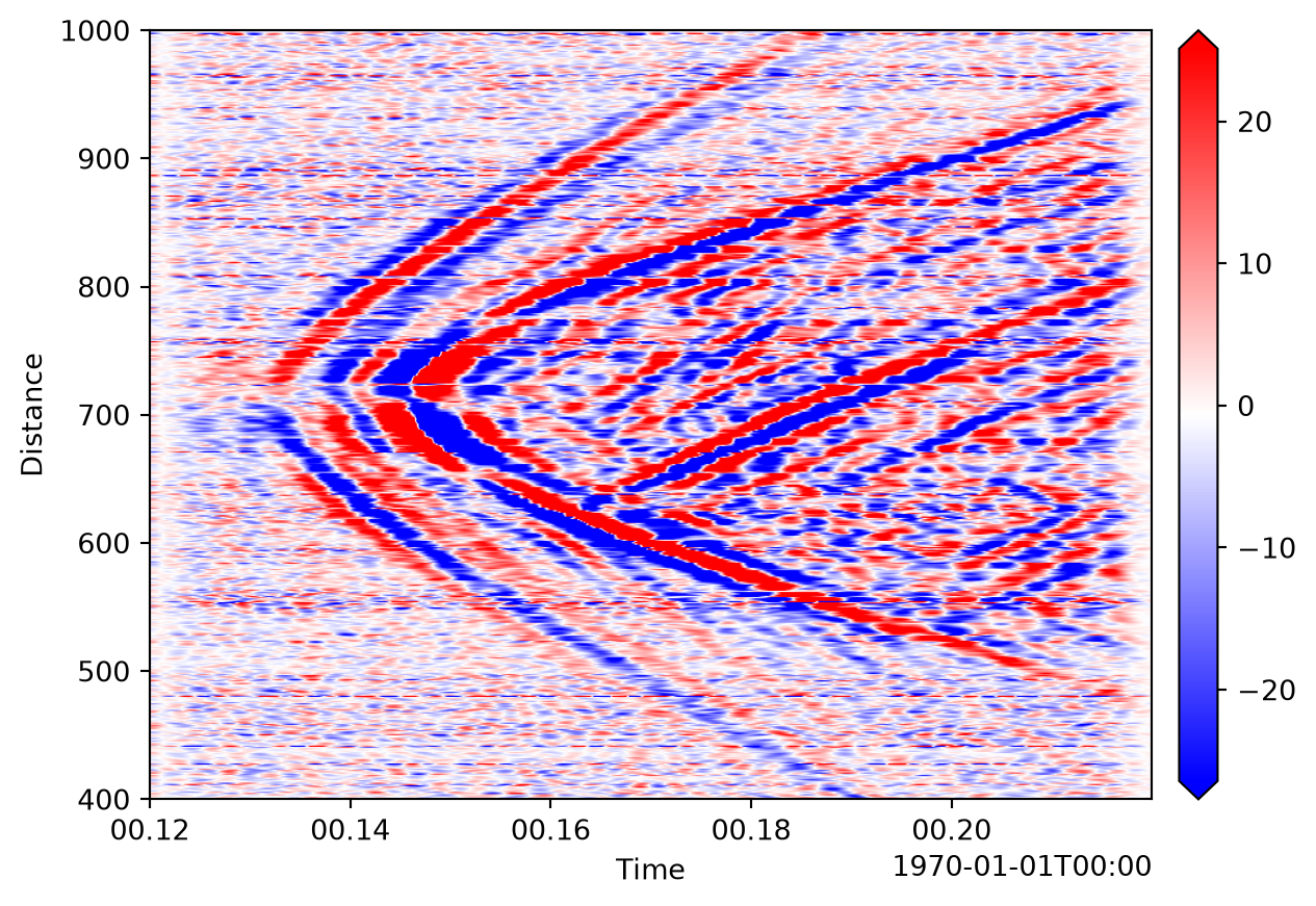
See the visualization tutorial for plot options.
Updating patches
Patch.update replaces data, coordinates, or the complete attribute model. Patch.update_attrs changes selected metadata fields.
scaled = patch.update(data=patch.data * 10)
retagged = patch.update_attrs(tag="processed")
Patch.update_coords modifies or adds coordinates. Tuple values specify (associated_dimensions, values).
shifted = patch.update_coords(time_min=patch.coords.min("time") + one_second)

latitude = np.linspace(41.5, 41.8, patch.shape[0])
located = patch.update_coords(latitude=("distance", latitude))

quality = np.ones_like(patch.data)
with_quality = located.update_coords(quality=(patch.dims, quality))
Several coordinates can be attached in one call, and the associated dimension determines the required shape:
longitude = np.linspace(-109.9, -109.6, patch.shape[0])
located = patch.update_coords(
    latitude=("distance", latitude),
    longitude=("distance", longitude),
)
The same tuple syntax works during construction:
rebuilt = dc.Patch(
    data=patch.data,
    dims=patch.dims,
    coords={
        "distance": patch.get_array("distance"),
        "time": patch.get_array("time"),
        "latitude": ("distance", latitude),
        "quality": (patch.dims, quality),
    },
    attrs=patch.attrs,
)
To change an association, pass the same values with a new dimension tuple. This changes coordinate metadata without reshaping the patch.
Coordinates not associated with a dimension use (None, values). Patch.drop_coords removes non-dimensional coordinates; dimension coordinates cannot be dropped. Patch.squeeze_coords moves non-dimensional coordinates holding a single value into the attrs.
detached = located.update_coords(latitude=(None, latitude))
without_latitude = detached.drop_coords("latitude")
Units
Patch.set_units changes unit labels without converting values. Patch.convert_units converts the data or coordinate values.
with_units = patch.set_units("m/s", distance="ft")
converted = with_units.convert_units("ft/s", distance="m")
Use set_units only when values are already expressed in the new unit or when correcting a missing label. Use convert_units when numeric values must preserve the same physical quantity. Data units are stored as Pint quantities and can be formatted with get_quantity_str. Dimensionless data, such as strain in m/m or a ratio of two patches with the same units, keeps dimensionless as its units, which differs from None (units unknown): convert_units("nm/m") scales dimensionless data by 1e9, but only labels data with unknown units.
Quantities may be passed directly to selection and processing functions:
from dascore.units import ft, m

selected = patch.select(distance=(10 * ft, 10 * m))
filtered = patch.pass_filter(distance=(10 * m, 100 * m))
Quantities are converted to the coordinate’s units before selection or processing, so the same expression works after a coordinate is converted from metres to feet.
Arithmetic and NumPy
Scalar and NumPy-array operations broadcast over patch data. Patch-to-patch operations require compatible metadata and align coordinates on their intersection; units participate in the calculation. See Patch compatibility for the shared rules.
scaled = patch / 10
offset = patch + np.ones(patch.shape)
combined = patch + patch

assert np.allclose(scaled.data, patch.data / 10)
assert np.allclose(combined.data, patch.data * 2)
Operations between patches first reject conflicting values in the configured patch_kind_attrs, then align shared coordinate values. Broadcast-compatible shapes are supported:
one_channel = patch.select(distance=0, samples=True).squeeze()
broadcast_sum = patch + one_channel
assert broadcast_sum.shape == patch.shape
Quantities update data_units as part of the arithmetic:
from dascore.units import s

velocity = patch.set_units("m/s")
displacement = velocity * (2 * s)
print(displacement.attrs.data_units)
1 mArray operands must broadcast against patch data. Coordinate-aware alignment occurs only for another Patch; a bare NumPy array contributes no coordinate or metadata information.
A bare array therefore follows NumPy’s rules: it lines up with the last axes, whatever the dimensions are called. Weighting a (distance, time) patch by a per-channel array w with patch * w scales along time instead, and raises nothing when the two lengths happen to match. To weight along a named dimension, wrap the array in a patch on that dimension:
distance = patch.get_array("distance")
w = np.cos(distance)
w_patch = dc.Patch(data=w, coords={"distance": distance}, dims=("distance",))
weighted = patch * w_patch
assert np.allclose(weighted.data, patch.data * w[:, None])
Comparisons such as patch > 0 give a boolean patch, which ~, &, | and ^ invert and combine, and which Patch.where accepts as a condition. abs(patch) is np.abs(patch). == is different: patch == other is Patch.equals, a single bool, so use np.equal(patch, other) for an elementwise mask.
mask = (patch > 0) & ~(patch > 1)
assert mask.data.dtype == bool
assert np.array_equal(abs(patch).data, np.abs(patch.data))
NumPy ufuncs operate directly on patches, and DASCore patch ufuncs support named-dimension reduction and accumulation.
absolute = np.abs(patch)
cumulative = patch.add.accumulate("time")
summed = patch.add.reduce("distance")
Patch.apply_ufunc also accepts a NumPy ufunc explicitly. DASCore maps named dimensions to NumPy axes and preserves compatible coordinates:
same_absolute = patch.apply_ufunc(np.abs)
scaled = patch.apply_ufunc(np.multiply, 10)
Named reduction removes the reduced dimension and coordinates which depend on it. Accumulation retains the original shape and dimension coordinates.
Other NumPy functions also accept patches. Unlike named reduction, np.mean(patch, axis=1) and similar reductions keep the reduced dimension at length one, with or without keepdims=True. np.transpose, np.swapaxes, np.squeeze, and the np.flip family call the matching patch methods, so the coordinates follow the data. np.diff labels each difference with the midpoint of the two samples it compares, drops coordinates which depend on the differenced dimension, and refuses prepend and append. np.gradient returns one patch per axis. Functions which sort values (np.sort, np.argsort, np.partition) and the numpy.fft functions raise a ParameterError, since no coordinates fit their output; apply them to patch.data, or use Patch.dft for Fourier transforms.
transposed = np.transpose(patch)
differences = np.diff(patch, axis=1)